Illuminating the Path to the Sea, Activating Blue Momentum—Guangzhou Maritime Safety Administration Supports High-Quality Development of the Shipping Economy in the Guangdong-Hong Kong-Macao Greater Bay Area
At the Pearl River Estuary, where the river meets the sea, shipping channels crisscross the waters. On the busy outbound routes of Guangzhou Port, large commercial vessels shuttle back and forth; along the western coast of Guangdong, offshore wind farms are under construction at an accelerated pace. With maritime projects like ports, bridges, and marine ranches advancing continually, the Pearl River Estuary and Guangdong's coastal waters are showcasing vibrant developmental momentum.
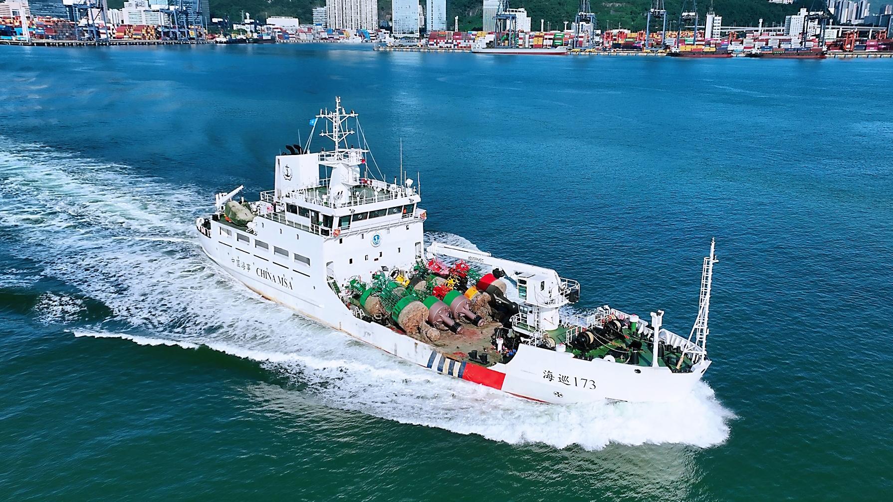
Driving economic development by relying on the ocean, maritime safety services are also expanding and upgrading. This year, the Guangzhou Navigation Mark Office under the South China Sea Navigation Service Center of the Ministry of Transport has focused on the needs of the Guangdong-Hong Kong-Macao Greater Bay Area construction and Guangdong's marine economy development. By adhering to its primary responsibility of navigation mark management, it actively engages with major regional projects, port and shipping industry upgrades, and emerging maritime industries. The office is accelerating the construction of a modern maritime safety support system, continuously enhancing waterway safety assurance and navigation environment monitoring capabilities, and providing precise, efficient maritime safety services to strongly support high-quality local economic development.
Proactive Services to Support Major Project Construction
Guangzhou Port's outbound channel serves as a crucial water transportation artery for the Guangdong-Hong Kong-Macao Greater Bay Area, with navigational capacity directly impacting port operations and regional logistics efficiency. Centered on the construction of Guangzhou Port's 200,000-ton channel project, the Guangzhou Navigation Mark Office actively engages with construction requirements, conducting navigation environment analysis and optimizing the navigation mark layout. By combining physical navigation aids with virtual AIS (Automatic Identification System) navigation aids, the office ensures safe passage while accommodating dredging and widening construction needs.
Wherever channel construction occurs, maritime safety services follow. This year, the Guangzhou Navigation Mark Office has adjusted and optimized 20 navigation marks in water areas covering Guangzhou Port, Chuandao, and Nanpeng Island, including setting up 8 new ones, removing 9, and adjusting 3, thereby enhancing the scientific and practical application of navigation mark layouts in key waters.
Maritime safety services have also extended to other significant transportation projects. From Huangpu Warehouse Terminal and Beijin Port Grand Bridge to Yuzhu Tunnel and Exhibition West Tunnel, the Guangzhou Navigation Mark Office proactively moves its technical services forward, intervening early in project navigation mark layout research, technical reviews, and measurements. It collaborates with construction units to optimize navigation mark setups during construction, minimizing the impact of engineering projects on vessel navigation. As of now, the office has completed 31 navigation mark technical reviews, 17 measurements, and released 93 updates on navigation mark adjustments. Applying navigation environment analysis in the pre-review stages of projects provides professional technical support for major water-related engineering constructions.
While ensuring engineering project safety, the Guangzhou Navigation Mark Office continues improving navigation safety governance in key water areas, advancing standardized and intelligent management of specialized navigation aids. Focusing on preventing vessel collisions with bridges, the office has actively engaged with management units of infrastructures like the Shenzhen-Zhongshan Channel, Humen Bridge, and Nansha Bridge, promoting the integration of bridge navigation aids into the remote measurement and control system of the Ministry of Transport's South China Sea Navigation Service Center. So far, 14 navigation aids on the Shenzhen-Zhongshan Bridge and 14 on Beijin Port Grand Bridge have been integrated. Together with related units, the office has conducted special clean-up of non-maintained navigation marks in Jiangmen waters, investigating and facilitating rectifications for 18 navigation marks. As of early November this year, 107 specialized navigation aids have been successfully integrated into the remote measurement and control system, improving real-time monitoring and collaborative management capacity for specialized navigation aids.
Navigation mark services connect one end to nautical safety and the other to millions of households. The Guangzhou Navigation Mark Office continuously provides maintenance services for navigation marks at key energy terminals such as Yangxi Power Plant, Zhujiang Power Plant, and Taishan Power Plant. This ensures the safe entry and exit of coal transport vessels, supporting stable energy supply and economic operation in the region.
Exploring the Blue Ocean to Foster New Maritime Industries
Along the western coast of Guangdong, offshore wind turbines rise above the clear ocean. As Guangdong's offshore wind power extends into deeper waters, offshore production facilities become densely distributed, mingling with navigating construction vessels, maintenance ships, and passing commercial vessels. Ensuring the safety of offshore facilities and vessel navigation has become a new challenge for maritime safety services.
For key offshore wind power projects like Yangjiang Qingzhou, Sanshan Island, and Fanshi, the Guangzhou Navigation Mark Office actively offers navigation mark layout and technical review services, ensuring vessels navigate safely during the project's construction phase. Recognizing the scale and clustering characteristics of offshore wind farms, the office systematically reviews wind farm submarine cable and navigation mark distribution in its jurisdiction. It conducts vessel navigation environment analysis for cable landing areas, provides visualized navigation risk information to stakeholders, and researches navigation safety protection solutions for clustered submarine cable zones. These measures provide technical support for the development of offshore clean energy.
From offshore wind power to deep-sea aquaculture, maritime safety services adapt to the new demands of ocean industries. In Yangjiang, the Guangzhou Navigation Mark Office actively participates in deepwater marine ranch comprehensive solution discussions and compiles navigation aid support plans based on the "Marine Ranch Navigation Mark Layout Guide." In Jiangmen Taishan, it collaborates with local departments to study navigation safety solutions for marine ranches, exploring navigation safety models tailored to aquaculture facility layouts and operating characteristics. Additionally, the office coordinates with Jiangmen's Provincial Nature Reserve for Chinese White Dolphins to push the establishment of new navigation mark layout and marine electronic fencing projects, combining navigation aid facilities with information technology to support marine ecological conservation.
From traditional port channels to offshore wind farms, from marine ranches to ecological reserves, the Guangzhou Navigation Mark Office continues expanding the scope of its maritime safety services, integrating navigation mark support into the development of the regional marine economy.
Empowering Technology to Build a Smart Maritime Safety Network
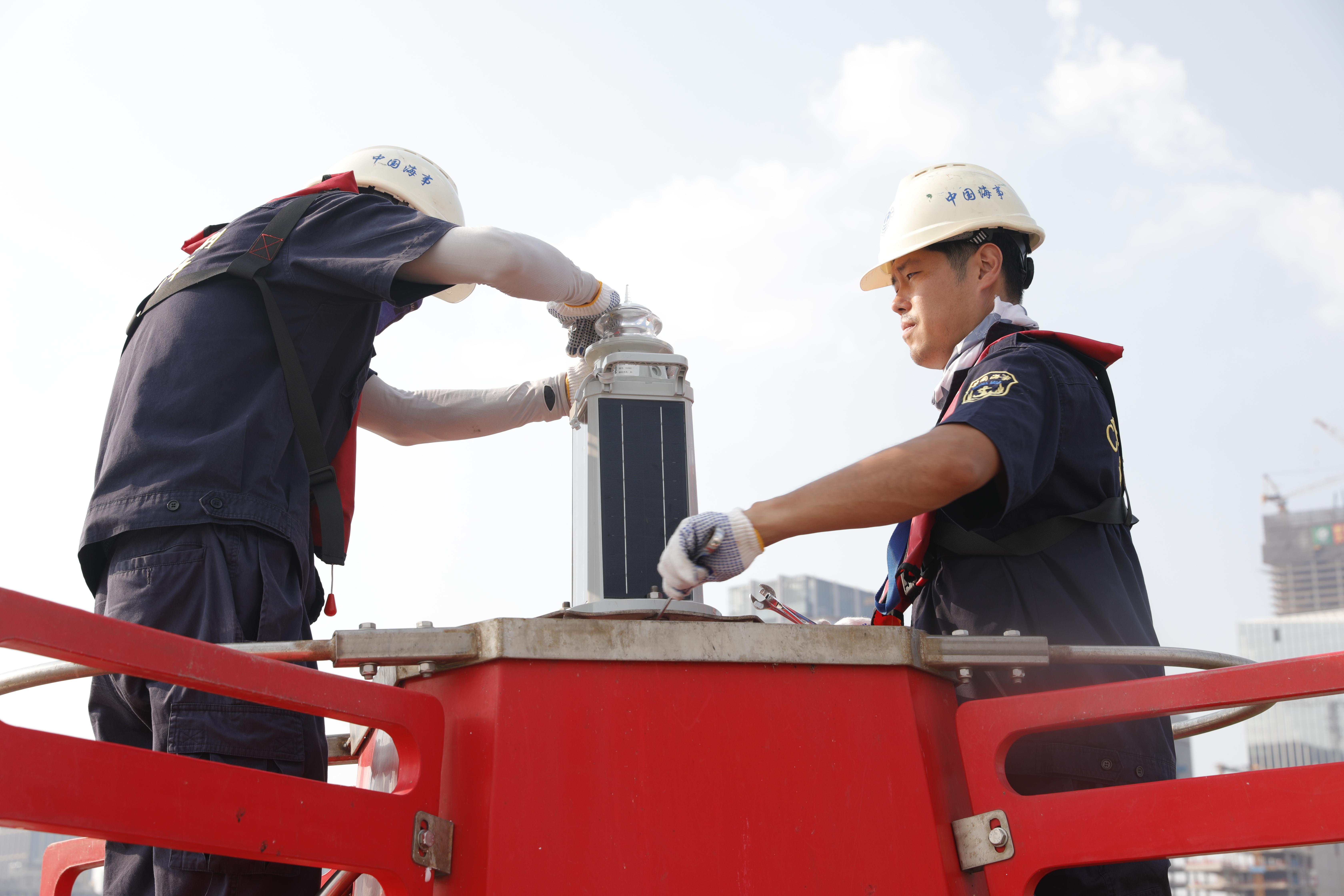
In the busy waterways of the Pearl River Estuary, navigation aids are being upgraded with new functionalities, transforming into intelligent "assistants" that sense hydrological and meteorological conditions and monitor the navigation environment.
This year, the Guangzhou Navigation Mark Office has continued advancing its multi-functional navigation aid infrastructure, deploying 9 units in key areas of the Pearl River Estuary, with plans to expand to 20 by next year.
Simultaneously, the office is cooperating with the Guangzhou Port Authority to promote the construction of multi-functional navigation aids in digital shipping channels. It has selected 9 illuminated floats in key port waters between Huangpu Bridge and Lingding Waterway for upgrades, equipping them with visibility sensors, current meters, wave sensors, sediment meters, and tidal gauges. A mechanism for routine data sharing has been established. Once operational, these instruments will enhance the capacity to collect maritime environment data and provide substantial data support for port operations, shipping decision-making, and smart channel construction.
While maritime nodes are being densely deployed, the coastal sensing network is also extending. Since 2025, the Guangzhou Navigation Mark Office has advanced the improvement of the South China Sea Coast AIS System, adding 39 base stations. To date, 112 AIS stations have been completed, enhancing the dynamic perception of vessel activities in vital waters and offering reliable information support for vessel safety navigation and maritime supervision.
From data collection to risk assessment, intelligent maritime safety services are increasingly applied. This year, the Guangzhou Navigation Mark Office has maximized its AIS data resource advantage. Using its independently developed "AIS Big Data Ship Traffic Flow Visualization Platform," the office employs distributed computing technology, converting huge amounts of dynamic vessel data into straightforward navigation status information. This offers technical support for navigation safety assessments for offshore wind farms, bridges, tunnels, and other water-related projects and optimizes navigation mark layouts. It has continued analyzing risks of commercial and fishing vessel encounters and assessing navigation safety during key periods. By scrutinizing ship trajectories, encounter situations, and risk distribution, potential collision risks in key water areas are identified, providing data support for the prevention of commercial and fishing vessel collisions.
Leveraging its data resource advantage, the Guangzhou Navigation Mark Office has also completed the development of a specialized analysis algorithm, integrating hydrological weather, dynamic water depth, vessel activity, and navigation aid data from multiple sources. This extends navigation environment analysis to comprehensive assessments and decision-making support. Meanwhile, the office employs innovative monitoring methods to assist related departments in tracing illegal AIS spoofing signals, offering technical support for maintaining order in maritime traffic.
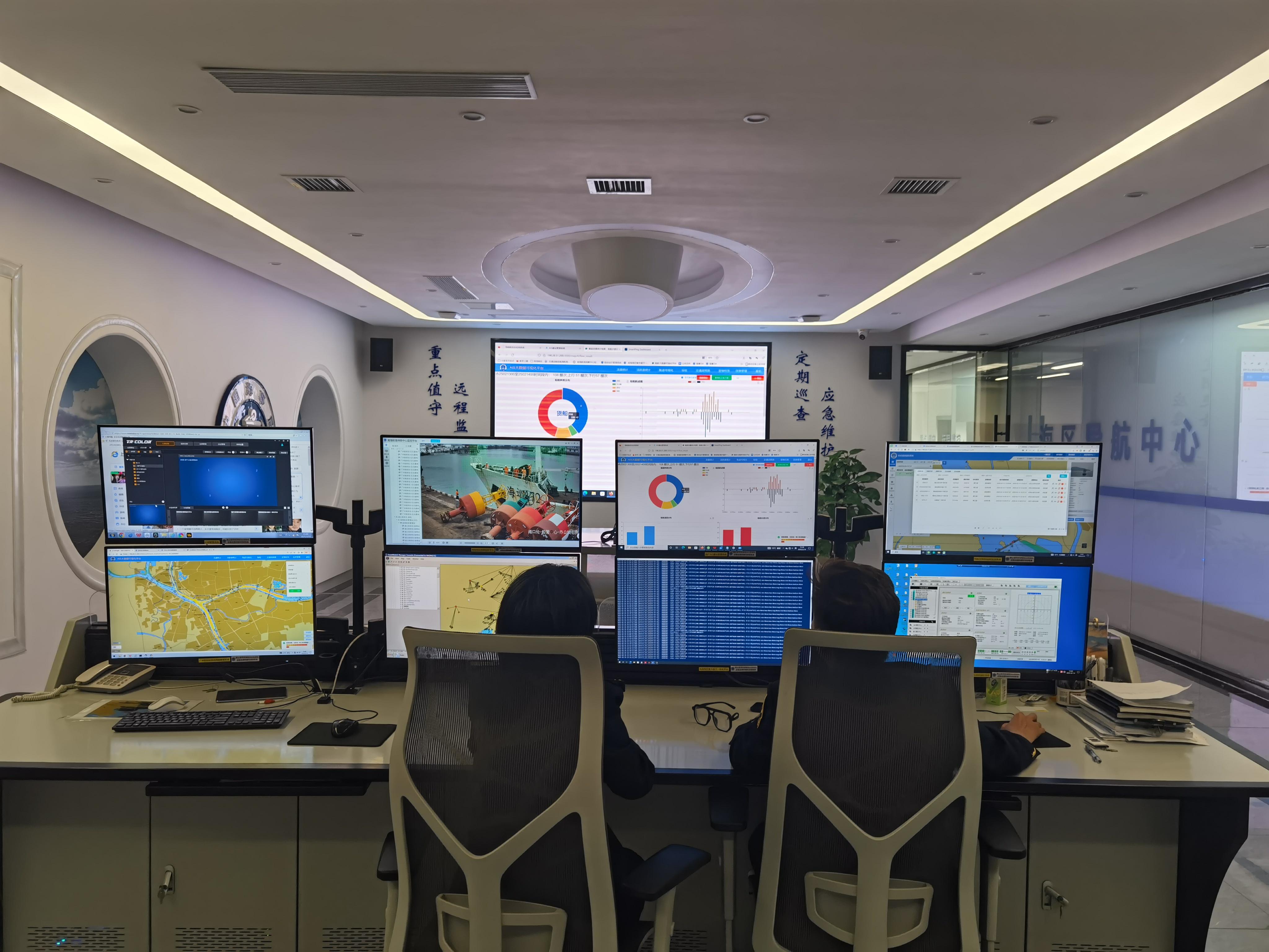
From upgrading navigation aid systems to enhancing vessel dynamic sensing networks and deepening data analytics application, the Guangzhou Navigation Mark Office is progressively building a smarter and more efficient maritime safety service system.
Navigation aids sense the ocean, and data serves navigation. Each navigation mark connects bustling ports with the vast sea, witnessing the region's strides in leveraging the ocean for economic development. Looking ahead, the Guangzhou Navigation Mark Office will continue to deepen the construction of a modern maritime safety support system, integrating navigation aid facilities, sensing networks, and data resources. With high-quality maritime safety services, it safeguards smooth waterways and contributes to the high-quality development of the Guangdong-Hong Kong-Macao Greater Bay Area and Guangdong's marine economy.
-
The cumulative cargo volume in the Ningbo section of the Hangzhou-Ningbo Canal has surpassed 50 million tons.4584
-
Illuminating the Path to the Sea, Activating Blue Momentum—Guangzhou Maritime Safety Administration Supports High-Quality Development of the Shipping Economy in the Guangdong-Hong Kong-Macao Greater Bay Area3435
-
"The Heroic Maritime Rescue Team's Seminar Held at the Party School"4072
-
"Research on the Planning of Inland Waterway and Port Layout in Liaoning Province" Passes Expert Consultation3449
-
November 03 International Shipping Trends5390